Monday 15 April 2019

Sunday ramblings...


As a non driver I'm ashamed to say my day off without Chris is usually spent binging on Netflix
and biscuits ...not today. With the internet not yet connected in our new apartment and hardly any phone data I decided to explore our new area.


I headed toward Stretford meadows and then west bound on the Trans Pennine Trail, first towards
Chorlton, roaming along the footpath and along the meadows then meeting the river which I
decided to walk along. I totally misjudged my way and ended up at Chorlton Green where I then
walked through the footpaths and met the Bridgewater Canal. The weather was dry and quite
sunny at the time so I decided to meander along there to see where I could end up. Stopping to
take pictures of cool graffiti and barges along my route.    


I travelled along Bridgewater Way to Sale, then Brooklands, Timperley and Altrincham - it was a
very busy morning with parents taking their children cycling, the rowing club out on the water
doing their thing.


I headed on, stopping only for a sip of hot coffee which I'd premade for if the weather got a bit
nippy. Which, hey, we live in Manchester - it always is.

I met my landlady along the way, up near Durham Massey- also out for some air this morning.
She recommended a tea room just a few minutes up the road to me, which sounded lovely, so
off I went.


Lavender Barn Tea Room was indeed lovely - my legs were starting to ache and I decided
I needed a break and a spot of lunch so I settled outside and ordered lavender tea (which I didn't
even know existed - but was great!!) And a good old cheese and chutney sandwich. Yum.
After breaking at the tea rooms for 20 minutes or so I set my way back deciding to take a
different route back home....then as per usual my phone decided to die, so my only way of
navigating back was via road signs and bus maps. I thought I'd never make it back anywhere -
my navigation skills being average at best!


From Dunham Massey I walked my way through altrincham (which seemed to be never ending)
headed toward timperley and brooklands and finally making my way back onto Bridgewater way
where the canal led me back to Stretford, my feet growing increasingly sore every single step.
All in all it was a lovely day out, I rarely do anything useful whilst in my own company so I did get
a sense of accomplishment for making it back to our home even as I struggle to shuffle into the
kitchen to make a nice hot drink on my poor, sore trotters.


Thank you for reading! <3

Saturday 13 April 2019

Bleaklow Bomber - Snake Pass part 2

Last month we went to Snake Pass in an attempt to have a walk around Bleaklow. The weather was insane, snow and wind prevented us walking even a couple of metres up the Pennine Way.
Today was our second attempt to see the area, the wind was still chilling, but bearable, and we could see our hands in front of our faces. So, no excuses.


We parked on Snake Pass, up high, as the Pennine Way crosses the road, and we joined the famous footpath headed north. The initial stroll was busy: young families and old ramblers chattered their way up the path. We caught conversation about the aircraft crash site that earnestly attracts people to these hills.


The path cut its way through the land, as though we were walking through a valley, on stones, sand, and (most often) mud. The people ahead and behind us branched off to the left towards High Shelf Stones, buy we continued along The Pennine Way. The clear marked path finally brought us to Bleaklow Head, beautifully marked with an impressive cairn. Even though the path was pretty much level, with hardly any incline, we were treated to a panoramic view of the surrounding fells, painted in browns, yellows and greens.


We turned back and headed south, it was our turn to make our way up to High Shelf Stones. With no clear path any more, we kept the hill in our sights and moved towards it, meandering left and right to avoid swamp and bogs and the many streams that slithered through the grass. Two massive natural rock arrangements, Wain Stones and Hern Stones, assured us we were going the right way, but between them there was nothing to keep us on track. Constantly checking the map and occasionally peeping through binoculars, we saw a few groups of people gathered and inched our way towards them.

As if out of nowhere, climbing up the very steady incline, we happened upon the wreckage. We had heard the story of the crash site, but nothing could prepare us for what we saw.


On the 3rd of November 1948, USAF Boeing RB-29A Superfortress, nicknamed ‘Over-Exposed’ crashed at the site, a few hundred metres from High Shelf Stones, whilst on a photography reconnaissance mission. Sadly all 13 members of it's crew were killed in the crash. The wreckage of the plane remains at the site as a memorial to the crew, and in 1988, a plaque was placed in memory of those who lost their lives.


What struck us was the surface area over which the wreckage was spread. The debris and mangled metal is to be found all over the place. A group of walkers slowly wandered through the site, but a few minutes later we were left alone with the ghostly ruins. Poppies and small wooden crosses scattered around the main part of what was once the plane, a respectful monument to the people who risk their lives in order to protect ours. It was a lot to take in, and was an interesting detour from the naturistic hikes we are now used to.

Silently continuing along our path, we finally reached High Shelf Stones, a busy summit with another picturesque panorama of the hills, and our first glimpse back at Snake Pass. We picked out or car from the line of parked cars on the layby, and started our walk west, to rejoin the Pennine Way, the path we had started a good few hours ago. Obviously stopping to pose for pictures for each other along the way, and of course arguing over which break in the terrain was our path. Standard!


Although there was no real difficulty in incline or terrain, I would recommend, if you plan to visit the area, you still plan for the worst. The open landscape can produce strong winds and poor visibility. If you plan to visit the crash site, I'd also recommend a map and compass, and some food and water. The walk from the road to the site would take less than an hour, but with no clear paths or distinctive markers, the potential to get lost still remains. That said, this is a gentle walk, with some very interesting for all ages things to see. A walk that will certainly stay with us for a long time.

Today we walked for 8.1 miles which took us 3 hours and 25 minutes, with one break and an extended stop to see the Superfortress’ crash site.


Bye for now.

Friday 5 April 2019

Idris' Chair

Hi there,

Jen here with my first blog post (be nice) about our few days away in Wales. Read on for wrong turns, dodgy stomachs and fire!

As it was our 2nd wedding anniversary (we haven't killed each other yet, Yay!) and my birthday, Chris arranged a super secret retreat away to Wales for a few days.

We woke up super dooper early, it was holiday time!

Now we definitely wouldn't be classed as early risers - we blame our super comfy bed that's just so difficult to leave. We set off around 7.30am for the 3 or so hour drive, with a few stops along the way to enjoy the scenery Wales has to offer, and my god does it?

We loaded up the car the night before so we could just get straight on the road and expertly managed to bypass most of the early morning traffic. We drove into Wales, along the North coast down into Snowdonia National Park and was astounded by the gorgeous views of the forests and mountains we passed, sheep playing in the field; many streams and waterfalls.

Our first stop was Betws-y-Coed which we had visited before on a lovely weekend away to visit Swallow Falls, we stopped for fuel (car and carbs - Chris opting for the biggest pasty I've ever seen in the shape of an Oggie, I don't think I've ever seen him so happy). We had a hike planned for the day already. As per usual it didn't exactly go to plan....

We arrived at the car park totally unprepared, for we had forgotten to stop for cash and the parking meter didn't take cards. So we had to drive back into the town to get some, before returning to the start of our route. We loaded ourselves up with our backpacks and essentials for the day and left from Dol Idris Car Park which was the start for the Minffordd Path of Cader Idris (found in our trusty Countryside Walking Magazine 100 best hikes in Britain book - which is treating us fabulously so far, I have to say!)


The sun was beaming down and it took us a while to get going, and I started to feel really unwell after about an hour and a half in. Despite my best efforts I had to agree to come back down. The mountain isn't such a great place to be when you aren't feeling 100% I won't go into details!


Instead we decided to go check into Nyth Robin, the beautiful campsite we were staying in for our short stay. Chris really pulled it out of the bag as far as birthday treats go with this place, it was stunning. Located not too far from Aberdovey, the cutest little seaside village. The campsite was a perfect spot to recharge our batteries and get some 'us' time in. We stayed in the Gwidihw Hut (Welsh for Owl) and we couldn't have asked for more. Very peaceful, cosy and a great place to spot the stars in all their glory on a clear night. Chris was triumphant in building a fire and we cooked and drank wine and discussed our plans for the next day...We decided to go back to Cadair Idris.


Fully refreshed and raring to go we woke up early to tackle the Minffordd Path, stopping at a lovely little bakery to settle our rumbling stomachs. All backpacked up and ready to go, we drove through the village, past lakes, rolling hills and mountains, back to the car park we had left yesterday. I was nervous, and definitely didn't want a repeat of the previous day!


The weather was equally beautiful but I definitely had more energy and gusto for the initial steep climb through the forest. Now it was a hard slog, don't get me wrong but we were eager to get on and get to our intended place.

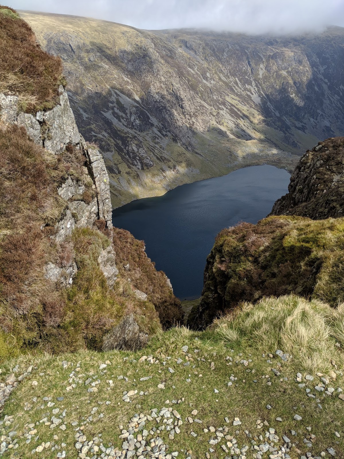
The scenery was gorgeous, few people around and plenty of spots to take great pictures. So quiet and calming despite the growing aches in my calves! We stopped a few times along the way to take in the scenery - we saw a gorgeous lake and on a day so fine, with the sun beaming down it was lovely to just be still by it and hear the rippling water.

Onward and upwards we went, surprising ourselves with each step further we got.
The weather turned the higher we went (as expected) and by the time we reached the summit it was pretty difficult to see. Our route had treated us well thus far but in all the excitement we had missread the directions and took a path leading directly down the mountain (bad choice) we spent a good 40 minutes carefully stepping through loose stones and rocks, scrambling our way down the mountain really not knowing we had now gone the wrong way and thought it better to concentrate on the terrain rather than double check our map! We didn't realise until we got to the bottom that we were in the complete wrong place. After a few arguments and checks of the map we decided to follow the only path we could see, despite this being in the complete opposite direction of the car, car park and the mountain, my plan was to not get stranded on the mountain - we weren't quite ready for that yet, and I'll be honest, more than a bit unprepared! Chris managed to find a route based on the direction I wanted to take, it would take us far, far away but it would be a direct route into the nearest town Dollegau.

We were tired, and a bit cranky but we finally got into the town - we needed to stop for chips and so did that whilst waiting for a taxi office to give me a call and let me know whether they had drivers available to take us all the way back to Dol Idris, a good 2 or more hours away on foot and we were spent! Unfortunately there wasn't a driver available so we waited for a bus which zoomed up straight there, we were back! We spent a while laughing and reminiscing about the hairy parts but we were happy, with a sense of achievement for not only managing to get to the top but for overcoming the twists and turns the day had for us in store.


Here are some of Chris' pictures:


Sunday 10 March 2019

Snow Chance! - Snake Pass part 1

Our plan today was to head up Snake Pass to the Pennine Way and along up to Bleaklow. Driving along snake pass the weather was treacherous, snow was smashing into the windscreen, the wind was blowing the side of the car, and visibility was terrible.
We opted not to stop near the Pennine Way, as the last thing we wanted to be doing on a freezing Sunday would be digging the car out of a foot of snow. We continued down the road until we found a better place to park.
The car park we found was opposite Snake Woodland, so we zipped up our jackets, put on our gloves and headed into the wood.


The wood provided us with some fantastic scenes, trees lightly powdered with snow, the rushing river splashing over the shiny rocks, and the brown and yellow of the trees and mud. We went a mile and a half into the wood before emerging at the other side to join the road we had driven down an hour ago.


Crossing the road, we decided to take a little rest, brush the snow and rain off our clothes, wrap up and tuck in for the walk ahead. This is when my glove flew off a wall and down a very snowy riverbank. Obviously, I was to retrieve it, but it was no easy task. I must have slipped over 4 or 5 times, with Jen stood at the top of the bank, wincing and pleading for me to come back. With the soaking glove in hand, I climbed, on my knees, back up to the road, ready to press on.
Unfortunately, the wind and snow made the walk into the Moors almost impossible, so we decided to walk along the road, back to the car, to warm up, have our lunch and drive back to the Pennine Way.

We stopped at the footpath, and covered our faces with scarves, and attempted our walk for a final time. The elements defeated us, and we surrendered. The wind made it almost impossible to breath, the snow was slippy and it was absolutely freezing!

We fully intend to come back soon to attempt the walk again. However today's adventure turned out to be a driving adventure as we explored the Snake Pass, Castleton and Winnats Pass from the warmth of our car. On foot we managed 3.50 miles, with no real change in altitude. It still counts towards our 1000 miles in 2019. 987 to go!

Thankfully, we got some lovely pictures of Snake Woodland.